Phase 2: Mexico to Montana via “Great Divide Route”
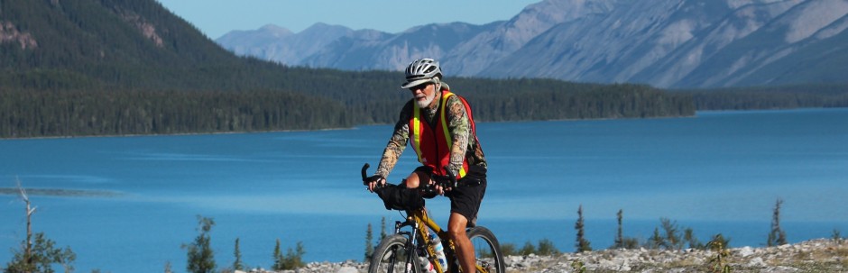
Aye Chihuahua! Finally, here we are in the Chihuahuan Desert. After many delays and lots of rescheduling we are resuming our bike journey from Key West to Alaska, albeit with some modifications. Last fall we started in Key West and rode as far as Fort Stockton, Texas, about 2200 miles. Because we are starting late in the season this year we have leaped over a couple hundred miles of Texas and New Mexico. We plan to catch those miles later this year. Our current plan is to mountain bike from the Mexican border to the Canadian border on the “Great Divide Route”. The GDR is a series of roads and trails on or near the Continental Divide. It is about 2500 miles long, of which nearly 70% is gravel, either Forest Service or ranch roads, maybe 20% is paved and the remaining 10% is single track trail. Betty is dropping me and my gear off in New Mexico and will stay with me through the desert, then she will return to Iowa. This plan will allow me to continue the next leg of our trip to Alaska and will free Betty to be with her parents. Plus, it’s a good excuse to get a new mountain bike.
25 May 2007: Day 1 – 45 miles from Antelope Wells, NM (Mexican Border) to Hachita, NM
We spent last night in a motel in Deming, NM. This morning Betty drove me to Antelope Wells, NM so I could start biking north from the Mexican border. Never heard of Antelope Wells, neither had we. All we saw were the border crossing stations. I explained to the border guards what we were doing, they seemed unconcerned. After unloading the bike and a few pictures I was on my way. This first section is on NM-81 a narrow paved road through the desert. There are no shoulders but there it almost no traffic so it doesn’t matter. The Chiuahuan Desert is the largest desert in North America, over 75,000square miles. Fortunately, it is partly cloudy today and the temps are in the low nineties.
Even though this is considered a desert (less than 12 inches of rain per year) it is sparsely covered with parched vegetation and has an active web of wild critters all trying to survive in a hostile environment. Lizards and toads are a common site on the pavement and road runners, hawks, crows and buzzards are all looking for their next meal. The road is mostly flat and straight, I suspect it will be some of the easiest pedaling of the entire trip: no hills and I am not carrying my camping gear.
Betty drives ahead and waits to make sure I am surviving and offers a cool drink. We can see distant mountains all around us, the closest are the low Hachet Mountains about five miles east of us. The last stop of the day is at the tiny village of Hachita (Little Hachet). It is nearly a ghost town, most buildings are boarded up, only the “Desert Store” is open. Hachita was a mining town (silver & copper) in the late 1800’s. In 1916, General “Blackjack” Pershing (with his aide Lt George Patton) based here as he organized the punitive expedition into Mexico searching for Poncho Villa. Several “firsts” surround these events: The first foreign invasion of the contiguous U.S. since the Revolutionary War and the first time motorized vehicles and airplanes were used in warfare.
OK, enuf of that, it was a long hot first day. I need to get acclimated to the heat, the elevation (about 4500 ft) and the pedaling. Betty whisked me off to Lordsburg, an air conditioned room, shower, cold beer and a Mexican dinner. I slept well.
26 May 2007: Day 2 – 27 miles/72 miles total; to Separ, NM (on I-10)
We saw an antelope on our way to Hachita, also several desert hares (similar to a small jack rabbit with black tips on their ears and tail). The skies are clear today so it is a bit hotter than yesterday but as long as I keep moving the self generated breeze feels good. We crossed the Continental Divide this morning, it was the first of 29 crossings along the Great Divide Route. No doubt it will be the easiest crossing, in the mostly flat desert it would go unnoticed if not for a sign: “Continental Divide 4520 feet”.
There are dozens of different kinds of cactus here and many are in bloom. The yucca has a stalk that shoots 3-10 feet above the plant and is covered with white flowers; they are everywhere.
As I ride north, I can see I-10 about 8 miles ahead across the flat terrain, only the trucks are apparent at this distance. They appear as silver boxes sliding in both directions over the landscape. Railroad tracks parallel the interstate. As two trains approach from opposite directions, it appears as if two worms are crawling across the desert toward each other, they become one then escape one another and crawl away from each other. (Maybe I’m getting too much sun).
Soon I am at I-10 and ride along a frontage road for 7 miles to Separ where I will meet Betty. Then it is back to Lordsburg for creature comforts.
27 May2007: Day 3 – 34 miles/ 106 miles total: to NM-90
Today will be all off the pavement on ranch roads. Since we don’t know the condition of the roads, Betty will drive back to Lordsburg and take NM-90 north to our stopping point, about 75 miles. I will go straight north about 34 miles to meet her. . In preparation for crossing 34 miles of desert, I load 5 liters of water, lunch and two Snickers bars.
While saying good-bye to Betty, she decides to drive the ranch roads and keep me supplied with water. Actually, I think she did not want to miss out on the first adventurous part of the trail. As I cross under I-10, I remember that almost exactly 12 years ago we were at this same point. At that time, we were riding horseback from the Atlantic to the Pacific and rode west along I-10 for several hundred miles. Now, I’m riding on a different kind of saddle, less comfortable, I think.
Betty keeps leap frogging ahead a few miles and gets some photos or reads while waiting for me to catch up. The road is smooth, packed sand and gravel, it is a good feeling to ride right out in the desert. Most places it is open range (no fences) with only cattle guards (metal bars or pipes crosswise to the roadway) to keep the livestock contained. We see some cattle, but hare, antelope and deer are more abundant. At one point I looked way up ahead and saw some large critter near Betty’s car. As I got closer I could make out a huge Brahma bull (about the size of our Honda CRV) and some cows crossing right next to Betty.
I knew the flat terrain would end soon, it was gradual. First, a few knolls to climb over, then some washouts to coast into, plowing through rutted sand at the bottom then more climbing. The smooth sand road became more rocky and the knolls became hills. This joy ride is fast becoming work! Neither the legs nor the lungs are ready for the climbs and the higher elevation; I’m from Florida for gosh sakes! I don’t look forward to toting all my camping gear over real mountains. After bunches of ups and downs, we top out on a ridge that runs along the Continental Divide (Elevation: 6300 ft) for nearly 4 miles, nice. Then, it was a steady decent for a couple of miles into White Rock Canyon. I braked most of the way down, not letting my speed get much over 20 mph. A section of the road with lots of loose gravel or soft sand could provide more excitement than I need. Signs of civilization start to appear: tracks on the road, a small electrical power line, an occasional side lane to a lone house, a car. Up to this point we had seen only one pickup truck with a couple of ranch hands. Suddenly, there is State Road 90, and green trees.
We load the bike and head into Silver City and one of the first things we see is a micro-brewery. A few beers and pizza later, we find a motel and I crash while Betty watches Sixty Minutes.
28 May 07: Day 4 – 24 mi/130 total mi: to Silver City, NM
It was an easy ride on NM-90 into Silver City. After lunch, Betty went to look for a laundromat while I started packing the gear, food, clothing, tools and spare parts I might need for the next few weeks. This is not an easy task, the essentials are a no-brainer, it is all the extras that might be needed that cause consternation.
Several weeks ago I had planned to use panniers (saddle bags) on both the front and back of the bike. After experimenting with them, I was not confident. The bike was really top heavy and unstable on gravel, especially down hills, also there was too much windage. In a cross wind the bags were like a kite causing even more stability problems. It was then that I remembered an observation from my good friend (and canoeing partner), Bill Quayle. After using bags on a “Northern Tier” transcontinental ride, he said a small trailer would have worked better. A little research and conversations with Keith Weary and other long distance bikers all supported the use of a trailer. This is a major change in planning and packing. The little “BOB” (Beast Of Burden) trailer arrived the day we departed Iowa for New Mexico. Dave Puffer, who runs Cresco Bicycles in Cresco, IA, helped me get it all together and gave me lots of tips about using a trailer. Dave pulled a BOB all over Central America a few years ago. It is a low single wheeled trailer that attaches to the rear axle of the bike. A large, waterproof cargo bag holds all the gear.
Now the problem is to reduce the amount of gear so the bag will close and still be waterproof, actually dustproof is more appropriate now. If I put my tent and sleeping mattress (ZRest) on the front rack and loose items, that may be needed often, in a handle bar bag, then I just might be able to get the cargo bag closed.
Silver City is a neat town, it is like an oasis after coming out of several days on the desert. It’s a small town, population about 10,000, and kind of down-to-earth trendy?? They had a Blues Concert on Main Street the day we arrived. Plus, it has a couple of micro-breweries and two bike shops J. Billy the Kid lived here until he was 15 years old and went on his crime spree. There are several large mines near here, the Santa Rita copper mine is one of the largest in the country. It is a strip mine with a crater 1600 feet deep and over a mile wide producing about 200 million pounds of copper annually. The weather here is great, warm and sunny in the daytime and cool at night with low humidity. We hope to come back some day and explore more of this area.
29 May 07: Day 5/37mi/167 total to CD
While Betty went into Silver City, I peddled on to the Santa Rita mine overlook. We met there and loaded the BOB trailer attached to my bike. It’s a bit unwieldy but I’ll give it a try. Betty departed on her way back to Iowa and I was off to points north. It was a steep decent into Membres, I braked to hold the speed down and stopped twice to let hot brakes cool.
About 6 miles north of Membres, I stopped at a Forest Service Visitors Center to get info about the next 140 miles of trail.This will be one of the longest stretches without resupply, 243 miles.
The climb up to the Contenental Divide was very steep and a twisted two miles. Once on top (7,400 ft) the trail follows the Divide along a ridgeline for nearly 6 miles (Divide crossing #3). After about 2 miles I found a beautiful site to pitch my tent, views for miles in all directions. After a dinner of Mac & Cheese I’m ready crawl in the tent and pass out.
30 May 07: Day 6/20mi/187 total miles to Black Canyon
These are 20 hard earned miles, Steep, rocky hills, without end.
The first five miles were beautiful, on a ridge line that is the Divide. There were some ups & downs but mostly easy peddling. I am on a seldom used Forest Service road, gravel and fist sized rock with some sand at times. The scenery is spectacular. Often with deep drop-offs right at the edge of the road providing incredible views.
Yesterday, Ranger Annette told me about some wild fires east of my route, today I could smell smoke. Once off the ridgeline, it was down a quite steep mountain side, constant braking. I stop every few minutes to let the hot brakes cool. I don’t know how much heat they can tolerate and still be effective, they sizzle when I spit on them. Brake failure would be disastrous, so I’ll not chance it. These brake breaks are not really a rest, I have to hold one of the brake handles tight to keep from rolling and keep the bike & trailer balanced upright.
Going up any more than a gentle slope is exhausting and soon requires pushing. The trailer is like a lead weight pulling backward. Even the pushing is difficult. Rest breaks going uphill require the same balancing act as downhill. This all equates to slow going.
The final descent today is long and steep, into Black Canyon. Even though going rather slowly, the rear tire went over a large rock and popped to the right, the downhill force of the loaded trailer pushed the rear of the bike more to the right and it was an instant jackknife. Now the whole rig is out of control and sliding sideways. I am still upright with one foot on the loose gravel. We come to stop still in a jackknife. Each effort to right the thing pushes us toward the side of the road, which drops off sharply. The trailer is on its side and I cannot upright the bike due to weight of the attached trailer. After several sliding attempts, I try to hold the bike with one hand and reach out to pick up the trailer with the other then release the brake enough to roll forward and get straightened and upright. Kind of tricky but finally we are up. There is no apparent damage. The remainder of the descent to our campsite was uneventful.
It is a beautiful camp, right on a fast flowing stream. I filled the solar shower bag and laid it in the sun to heat while I set up camp, washed clothes, purified five liters of drinking water and cooked dinner (Alfredo with broccoli). Both the meal and the shower were great.
31 May 07: Day 7/17mi/204 total to Wall Lake
What a great campsite this has been, beside a rushing stream, nobody within miles, full moon; really peaceful, I slept well. It was cool last night, glad brought a 20 degree bag instead of the lighter and more compact 40 degree one I usually use.
While checking over the bike before departing, I found that the trailer tire was flat. I took out the tube but could find nothing wrong with it, so I stuck back in, pumped it up and started. It was a late start and a long, steep, rocky climb out of Black Canyon; it took one and a half hours to push up the 2 miles. Then lots of ups and downs. Had tuna & peanut butter crackers for lunch on top of ridge.
About 4 miles from today’s end point, this Forest Service road had just been graded. I saw the fresh tracks where the grader operator had turned around to grade the other side of the road on his way back. This made it extremely difficult for a bike. The grader had plowed out the ditches leaving 4 to 8 inches of dirt, small rock and sand covering the road. I had to push through soft layer for nearly 3 miles. Each time I spotted a small lane scraped clear and tried to ride, I would soon get mired and wipe out if I tried to continue riding. About a mile prior to Wall Lake, I saw the grader off to the side in a clearing. The operator was done for the day and was cleaning up his rig. I could not pass this opportunity to vent. Edgar was a nice guy but unsympathetic. When I asked why he layered the road so deep at one time, he said: “Hey, we only maintain these roads once a year and we have to clean the ditches so the summer rain storms won’t erode the roadway.” Additionally, he said this road is being graded all the way to Pietown this week by another operator. And, that I should check with the Forest Service’s Work Outpost at Beaverhead, about 10 miles on up this road.
OK, for now I’m on ungraded road sailing downhill toward Wall Lake. An elk runs across the road only a hundred feet in front of me. I find a spot to pitch on a slope overlooking the lake and some red rock cliffs. While quietly preparing dinner, a doe mule deer browses a few hundred feet away.
Cooking at this elevation takes longer, water boils at a lower temperature. This pasta & veggie meal is usually done in about 7 minutes but at 12 minutes it is just getting edible. The past three days the trail has touched 8000 feet, I am camped at 7600ft.
The trailer tire held up for the day but is a little soft now. I’ll replace the tube tomorrow morning.
1 June 07: Day 8/32 mi/236 total to Winston for resupply.
It was a breeze peddling the couple of miles to Beaverhead,mostly downhill not yet graded. Clyde, a young Forester told me that the next section is not nearly as rugged and that the wide Plains of San Agustin are reasonably flat. However, he also said that about 25 miles had already been graded and they will be working on the rest of it next week. He suggested an alternate route that is not being worked, but is about 15 miles longer. Great!
So the plan is ride a mostly paved road to Winston to get supplies and tomorrow ride north on a gravel ranch road. Going to Winston is 11 miles out of the way (22 total) but I need to resupply and want to mail some items home to reduce weight.
It was good to be on pavement again, the miles go by much faster and with less effort. Crossed the Divide again. Clyde passed me a mile or so before I turned south for supplies. When I got to the intersection he was waiting and offered me a ride to Winston. We tossed all my gear in the back of his pickup. It is Friday and he was on his way home for the weekend. He told me Winston was having their annual Festival celebration this weekend.
Winston is small, about 50 people. An empty RV campground allowed me to pitch for free. The store across the street had a shower for truckers and BBQ sandwiches, just down the street was the Diamond Saloon. Hey, things are looking up. During the evening I met nearly everyone in town plus many that come back every year for the Festival. Patrick Pyle played the guitar and sang western songs all night. At one time there were probably 20 in the Diamond and I was the only one not wearing jeans, including the women & kids.
2 June 07: Day 9/30 mi/266 Total to ?
Got packed, mailed package, watched parade. The parade was at 11:00 and I rode out at 11:30. The first 11 miles were paved that got me back on track, then I was on the gravel ranch road. Soon I was crossing a portion of the Plain of San Agustin. This is a huge high mesa with rolling grasslands spotted with sparsely forested hills. Mostly good riding, sometimes I got bogged down in loose gravel. Lots of cattle and cattle guards, at times cows were standing on the road.
3 June 07: Day 10/45 mi/ 311 total to Datil
Almost total cloud cover this morning, first time it hasn’t been blue skies.
Had a fitful night.
Each time I would start to fall asleep I would sit up startled and anxious. The tent seemed confining and I had to get outside. After four or five such events, I thought I was going crazy then recognized what was happening. I had altitude sickness (mountain sickness). Nine years ago when I was hiking the Colorado Trail I had similar symptoms. Same thing then, after about a week on the trail at a high altitude, I did a 27 mile day crossing Georgia Pass in order to meet Betty and our niece, Tiph, in Breckenridge. Betty had rented a neat rustic pioneer cabin that was well over one hundred years old. That night I nearly drove them both crazy. Up & down, sleep in the loft, swap beds, sleep near the window, turn the heat off, etc. I even tried sleeping outside. After a couple of nights without sleep, I went to a doctor who immediately diagnosed it, prescribed some magic pills and I was cured within a couple of hours.
OK, now I need to find someone who can prescribe magic pills and I am 50 miles from no place. I decide to ride to the nearest little town and work out something from there. It is 30 more miles north on this ranch road,then 15 miles west on US-60 to the small town of Datil.
Early start (I was already awake), rolling hills still on the Plains of San Agustin, wide seemingly level expanses; the miles go by quickly. Since leaving Members several days ago I have seen an average of 3 vehicles per day. While on the Forest Roads it was mostly Forest Service trucks, now it is mostly ranch pickups pulling stock trailers. Most drivers wave, only 3 have stopped to ask if they could help or maybe they were really just inquisitive. After about ten miles, I can see large white satellite like dishes in the distance. As I move north, every hill top brings more into view. They are spread over miles in a methodical array across the Plains. What? Some kind of “ET” operation, New Mexico has a long standing reputation for spooky outer space stuff.
Some of the dishes that were in clear sight are now dim & darker, lightning flashes clear bolts straight to the ground near them. Wind direction, flash to bang time, cloud movement; hey this thing is coming my way. Foolishly, I think I can ride out of its path, not! I coast to a stop in a low spot, push the bike against the 3 foot bank across the road ditch,toss my tarp over the bike and crawl in under it. Sprinkles are already hitting the tarp. As the wind picks up, I tuck in the tarp as best I can and try to hold it in place. Now it is raining hard, big cold drops chill through the thin cover. Lightning cracks loud, hard and bright close by, but fortunately, not too close as I remember that I am hunkered up against a metal bike, hummm.
Almost as quickly as it came, it is over. Tarp, bike and trailer are splattered with mud, but all is well. The air is cool, I am damp and chilled, I push hard to warm up.
A mile or 2 ahead, I can see a dark spot in the road, a vehicle, an animal, somebody to talk to? Closer and it is obviously a black cow and there are lots more on both sides of the road. Two young bulls are going head-to-head raising clouds of dust, a real bullfight. They are all spooked when they see this strange contraption coming at them. There are over 50 of them and they start running in all directions, crossing and recrossing the road. I stop to allow the confusion to settle. Finally, they all gather on the left side, unfortunately there is a fence about 25 feet away from the road while the right side is open for miles, they are blocked between the road and the fence in a narrow strip. I ride slowly on the far side of the road, but no good they trot ahead, next they are running hard. I have inadvertently caused a stampede. They are way ahead of me, maybe a half-mile, and still going strong. These are some “in shape” cattle. After a couple of miles, there is a gate on their left, they run through it and out onto the range. Whee!
Cresting the next hill, I see that a young bull missed the gate and ran on up the strip. He faces me and we watch each other as I approach. Only a hundred away and turns and runs ahead, a mile, then another, finally he slows. It is on a long down hill stretch, I decide to whisk past him. He runs hard but my momentum going downhill is too much for him and I slowly pass the critter. I look back and he is standing watching me disappear, I suspect he is as grateful as I am.
Three miles south of intersecting US-60, a sign marks a road off to a cluster of buildings to the west. It is the National Astronomy Radio Observatory’s Very Large Array. There must nearly a hundred of these huge dishes (each about 40 feet high). As I turn west on US-60, I ride right through a line of them.
Datil is 15 miles away, straight, mostly level and boring. Shucks, the only store in town is closed on Sunday. There is an RV park behind the store with only 2 RVs. A new neighbor says “Set up now, check in at the store in the morning”. I pitch, wash clothes, wash me (there is no bath house) and cook dinner. Hope to get better sleep tonight.
4Jun07 – 10Jun07: 0 miles/311miles Total
Last night was more of the same, no sleep.
On 4 June, I contacted the local EMT in Datil, the only medical service within 30 miles. They listened to my tale of woe, checked vitals and made arrangements to get me to a clinic in Sorroco, NM. The Nurse Practitioner, ran a few basic tests and determined I should go to a hospital for more tests, rest and further evaluation. I tried to convince her that if I could just get a prescription for Diamox, I would be OK. She felt otherwise due to elevated blood pressure, erratic pulse and other indicators. We struck kind of a compromise; she would get the prescription and I would return to Datil, but I would get a more complete evaluation if I did not get a good nights sleep and if BP & pulse were still abnormal.
Drats, another night without sleep. Those darn pills worked like a charm a few years ago, now they had no effect whatsoever. Tossing and turning, all night I was positioned with my upper body outside the tent so I could get more air and avoid the claustrophobic feeling of being inside. After one of the panic attacks, I made the decision that I had to have sleep and that I would get to a lower elevation and would take a break from the biking until I could find out what was happening.
The next morning, I asked the kind folks at the little store in Datil if they knew of anyone going to Socorro. I wanted to get me and the bike plus gear to a rental car agency and would drive back to Iowa and a medical evaluation. Good news, John Delong is pulling a trailer loaded with tree limbs to Socorro and is willing to let me strap my bike on top of the pile. Bad news, when we get to Socorro, none of the three rental agencies will rent “one way”. John agrees to take me on into Albuquerque, a hundred miles each way. I agree to pay for the gas and lunch.
National Rental Car, 1445 miles and I am now in Iowa with Betty. I feel normal (good) and am sleeping well, but have an appointment for Wednesday, 13 June to get a medical check-up. We will determine what we will do next based on the results.