Saturday 9/16/00 23 miles/3832 Total. 238 Trail Days. Little Wilson Falls to Katahdin Iron Works Road. Betty drove us the 50 miles plus to our drop off point, then “Mississippi Hiker” and I had a mile hike on a connector trail to reach the AT. Of course, the extra mile does not count in our miles hiked for the day because it is not on the AT.
Within an hour after intersecting the AT, we had to ford Big Wilson Stream. It was a little over knee deep and about one hundred feet wide. The roar of the rapids added to the drama. “MH” was wearing low cut hiking boots that were still wet from yesterday’s rain. He removed his socks and wore the already wet boots to cross. I was wearing dry leather boots and I hoped to keep them dry so I slung the boots over my shoulder and crossed barefoot. The water was chilly and swift, but the crossing was uneventful. Next, we had a long climb up the Barren Chairback Range. We crossed several peaks on this range so the hiking was mostly up and down.
We knew that 24 miles was cutting the available daylight pretty close; sunset is about 6:45PM. We hiked fast all day trying to reach our rendezvous point before dark. It was 6:50PM when we saw that beautiful, mud covered diesel pick-up truck and Wayne waiting to whisk us away to civilization, such as it is here in the north country.
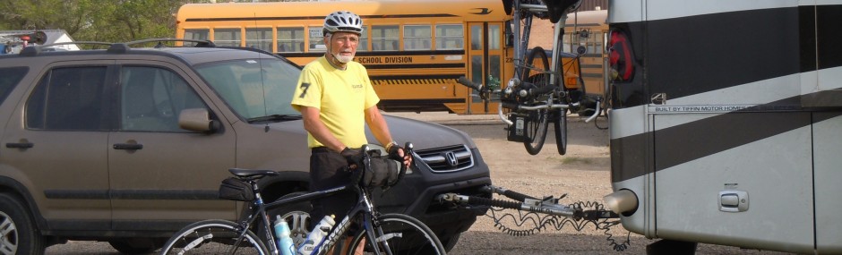
Betty: After the guys showered, we all headed into Milo for pizza. Tomorrow, Sunday, we will move the RV’s forward to Jo Mary Lake Campground. It’s between Milo and Millinocket. It’s on land that belongs to one of the paper companies. Because the roads are owned by the paper companies in this area, you have to pay to use them, and it’s $7 per person per day. However, if you camp in the campground the cost is figured into the campground fee. For us it works out better since we will use their roads for three days. We will be camped right on the lake. Nice. We will move to Katahdin Shadows Campground in Medway on the 20th.
Sunday 9/17/00 21 miles/3853 Total. 239 Trail Days. Katahdin Iron Works Rd to Crawford Pond on Kokadjo Road. Wayne had “MH” and me on the trail by 6:30AM. Our first order of business was to ford the West Branch Pleasant River. Today, I had my Teva Sandals and it was an easy crossing. Then it was a long steady climb up White Cap Mountain (3654 ft). It was eleven miles and six hours before we reached the summit. On top, the wind was about 25 mph and the temperature 35 degrees with a cloudy mist; we did not tarry.
During the day we saw several (maybe six) ruffed grouse and one spruce grouse. On the drive to the trailhead this morning we saw a cow moose. It ran down the road in front of us for a hundred feet or so before moving into the bush. Moose sign is all along the trail.
We arrived at our meeting point early and Betty drove up just a few minutes later.
Monday 9/18/00 7 miles/3860 Total. 240 Trail Days. Crawford Pond to Jo Mary Road.
What a great day. The sun was shining on Maine today. Wayne took Betty “Honeycomb”, “Virginia Bluebird”, “Mississippi Hiker” and me to the trailhead. It was a beautiful hike along Cooper Brook, easy trail, easy pace. We stopped at Cooper Brook Falls Lean-to for a short break. It is interesting to read the trail register and check on the progress of other hikers.
Wayne was waiting as we all arrived at Jo Mary Road (Jo Mary was an Indian who lived in this area).
My sister, Mae, arrived at the RV park late in the afternoon. We had some great tasting 15 bean soup that Wayne prepared, then we all sat around a campfire on the lakeshore. The large land mass of Katahdin stood proudly beyond the far shore of the lake. It was good to have Mae “Crabby Trails” back on the trail with us.
Betty: Originally, Mae and I had planned our meeting point and we were going to move the RV to Medway on the 17th. Mae’s plans then changed, and in the meantime we found the campground at Jo Mary Lake. When Mae headed to Maine from Indiana, I had not updated her on where we were. I called Indiana and found she was already on her way. So, I called the RV park in Medway (Katahdin Shadows) and explained the situation. They said they would give her the message and tell her where we were. Today, since our hike was a short one, we were in early and I figured Mae would be arriving mid to late afternoon. I needed some groceries and knew the town was in a cell phone friendly area, so headed into town. I was holding the phone up to the window as I was driving in order to pick up a signal and it rang. So, I said “Hi Mae”. It was, and we met at the store. It all worked out fine. We’re happy to have her back here with us once again.
Tuesday 9/19/00 20 miles/3880 Total. 241 Trail Days. Jo Mary Rd to Nesuntabunt Mtn. Road.
Betty and Mae drove “MH” and me to the trailhead. It was a flat, fast hike to our lunch stop at Nahmakanta Lake. It was here that we would meet any of the others in our group that wanted to hike the remaining 5.5 miles.
While there eating lunch, “Mousetrap”, “Welches”, “Moses” and “Magnum” arrived. After a short break, they moved onward. Betty and Mae arrived shortly afterword. They hiked with us the latter half of the day. It was a good hike by Wadleigh Stream Shelter and up Nesuntabunt Mountain. Betty and Mae paced themselves well, we took a break at the summit.
Wayne and Mary were waiting for us at the road crossing. We were all glad to see them. It was another great day on the trail.
Betty: The mushrooms, mosses and lichens along parts of this trail were incredible. Some of the mushrooms were as big as dinner plates. A beautiful day and a wonderful hike.
Wednesday 9/20/00 20 miles/3900 Total. 242 Trail Days. Nesuntabunt Mtn Road to Abol Bridge.
It was a foggy morning and the temperature was warmer than usual. Betty and Mae drove us the 21 miles through some of Maine’s most remote roads to the start point.
“Mississippi Hiker” set a brisk pace as we moved alongside Rainbow Stream then Rainbow Lake. The view of Katahdin from Rainbow Ridge was inspiring. It is strange to think that in just two hiking days I will summit. “MH” will wait until the 28th of September when his wife and son will arrive.
About four miles from our destination for the day, we stopped at Hurd Brook Lean-to. This is the last trail shelter on the Appalachian Trail for northbounders. “Moses” was there reflecting and making notes in his personal journal. All the hikers we have talked with recently are beginning to experience the bittersweet feelings of completing a long hard hike and knowing that this great event is about to end. Many have developed the strongest friendships of their lives. Moses hiked with us to the Abol Bridge. Along the way a sign indicated that we were leaving the One Hundred Mile Wilderness. The Abol Bridge crosses the West Branch Penobscot River. A small store near the bridge had cold beer and we relaxed at some outdoor picnic tables with “Welches” and others. Wayne and Mary arrived and took us back to our new RV Park in Medway.
Betty: After driving “Swamp Eagle” and “Mississippi Hiker” to the trail, Mae and I started getting the RV ready for the move. We departed Jo Mary Lake around 10:30 AM and moved to Katahdin Shadows RV Park in Medway.
Thursday 9/21/00 10 miles/3931 Total. 243 Trail Days. Abol Bridge to Katahdin Stream Campground. Wayne drove “MH”, “Virginia Bluebird” and me to the start point at Abol Bridge. It was an overcast day with the prediction of rain. The trail entered Baxter State Park and was very scenic, first along the Penobscot River, then along Nesowadnehunk Stream.
At Daicey Pond Campground, “Virginia Bluebird” found the small lodge that her Great Aunt and Great Uncle visited annually for over 20 years. “VB” had a photograph, taken in 1964, of the lodge. It is now called the Camp Library, but is definitely the same building. It is a rustic one room building with a small porch overlooking the lake. Baxter State Park has no electricity, so the building has gas lights and a wood burning stove. Old photos and bookshelves line the walls. Most of the books are over 30 years old, some over 50 years.
While at Daicey Pond Campground we were required to register for our hike up Katahdin, it was a pleasure. Less than three miles later, Betty and Mae met us at Katahdin Stream Campground.
Later, the Howells met us at the Appalachian Cafe in Millinocket for dinner. Several other hikers were there. Excitement was in the air.
Betty: Baxter State Park has several campgrounds, however they don’t take RV’s the size of ours and they don’t allow pets, so that is why we didn’t stay at the park.
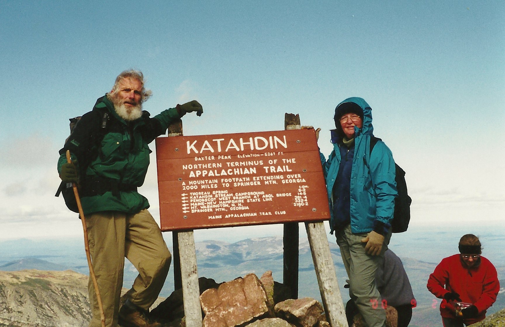
Friday 9/22/00 11 miles/3941 Total. 2167 on the Appalachian Trail. 244 Trail Days. Katahdin Stream Campground to Baxter Peak (Katahdin) and back to Katahdin Stream Campground.
Up at 4:30AM, a quick breakfast then a 36 miles drive to Baxter State Park. The park opens at 6AM and by 6:15 we have our permit and the weather briefing required to climb to Baxter Peak on Katahdin (elevation 5267 feet). We are told there would be no precipitation and that the cloud cover should clear, the good news. We are also told to expect winds above treeline to reach 50 mph and temperatures as low as 30 degrees. My chart shows this to be a windchill of minus 2 degrees. We all had warm clothes and windbreakers, but 50 mph is still a little much.
Our plan was that Mae, Betty and I would get an early start, hike up Katahdin Mountain to Baxter Peak, then hike back down the same trail to our vehicle. The Appalachian Trail ends at Katahdin. I plan to hike back down the mountain then walk along a gravel road that goes around the east side of Katahdin’s base then north a day or so to exit Baxter State Park.
We logged in on the trial register at 6:50AM and started the long hike up this famed Mountain, a 4,000 foot climb. “Mousetrap”, “Magnum” and “Welches” were also summiting today, they hiked with us a few minutes then moved on ahead of us. The trail was rocky with lots of roots and graded upward. We crossed Katahdin Stream on a footbridge near the falls and the trail became steeper with larger rocks. Soon the climb was even steeper and often over boulders. Our progress was slow. At about 3400 feet we were above treeline and the wind was about 20 mph. The steep climb up to Hunt Spur was through a large nearly vertical boulder field. Climbing over, around and between these huge boulders and rocks was time consuming and tiring. Finally, we made it over Hunt Spur and along a ridge then it was up through another large, vertical boulder area. This steep climb led up to another spur called The Gateway. The exposure on all these areas was considerable with sharp drops of hundreds of feet.
During the climb up to Hunt Spur, we were all moving slowly and I noticed that Mae was having difficulty moving her legs especially on long or high stretches and reaches. She and Betty suggested that they return to the parking area so that I could make better time. But when I said I would go with them, they elected to press on. About half way on the climb up to The Gateway, Betty was leading and did not know that Mae stopped for a break. I waited with Mae and she said she was not going any farther. She wanted to rest there in a protected nook tucked in the rocks while Betty and I continued to the summit. Her little site was right alongside the trail and she was wearing warm clothes under her windbreaker. At this point, I knew that she needed some time to recuperate before heading back down. She promised not to try to go back down until we returned and I went up to catch Betty.
It was slow going with strong wind and exposed areas, but we finally crossed The Gateway and were on the Table Land. This is a huge, flatter alpine area strewn with smaller rocks. We could see the trail winding up through the Table Land and then more steeply up to the ridge leading to Baxter Peak. The going here was much easier and we were soon standing at the summit. This was a momentous occasion; it was the end of the 2167 mile Appalachian Trial which started at Springer Mountain, Georgia. The sky was only partly cloudy and we had a beautiful 360 degree view. The wind was less than 25 mph and the temperature in the thirties, much more comfortable than predicted. Icicles were hanging from rocks and from the back of the summit sign. We got a couple of pictures and quickly started back down.
As we were departing, the gravity of the moment swept over me. I thought of all the people who had helped me get here and wished that they could be here to experience the same exhilaration. Foremost in my mind were Roger Rose (“Boca Pete”), Frank Mazza (“Natty Bumpo”), Susan, EJ and the grandkids, Linda and Sam Sloffer, Roger Warren, Scott Sheldon and so many others that have helped us and joined us. I was extremely glad that Betty and Mae were along to share this day with me; they have made this possible. I was especially happy to have Betty enjoy the summit, she was also with me on Springer Mountain. Her total commitment to this long trek has been unfailing. This was a very satisfying few minutes.
Betty and I moved down as fast as we safely could. While slowly climbing over The Gateway and through the large boulders, we saw Mae waving, and I think I saw a smile. We were relieved to know she was feeling better.
The three of us slowly negotiated down through the same route we had worked so hard to climb through on the way up the mountain. Soon, it was late afternoon and we knew we were racing the sun. The sun won. By the time it was totally dark we still had over a mile to go. My little flashlight was inadequate for the three of us to move any more than a snail’s pace. Plus, I knew the little “triple A” single cell would not last long, so we were using it sparingly.
Mae said she heard a phone ringing, it was Betty’s cell phone, but by the time she dug it out of her pack the caller had hung up. We suspected that it was the Howells, who would be concerned about us. Soon it rang again, it was “Mississippi Hiker”, Harold Howell. We assured him that we were all OK, but that with our slow pace the flashlight would surely give out before reaching the parking lot. I suggested that he call Baxter State Park and ask if a ranger could meet us on the way down. It seemed like only minutes when Ranger Bruce White was approaching, his light bobbing along the trail was a welcome sight. He had a pack full of large flashlights and gave each of us one. We quickly hiked that last half mile and were relieved at the parking lot. Our great thanks to our friends Harold, Wayne and Mary and to Ranger Bruce. It would have taken two or three hours longer without their help.
What a day!!!
Betty: When you read about those last hours it will be hard to imagine, but remember we were out in the wilderness with no reflected light from anything. At about 7PM we were in total darkness. We were still hiking over and around large rocks, some of which Mae and I just sat down on and slid off, rather than falling off. There were many roots and our legs were like jello, buckling under us whenever we tried to step off of something. The three of us fought through these conditions until about 9:30 when Ranger Bruce arrived. He arrived when we were about 3/4 mile from the parking lot and even with flashlights it took another hour to get off the trail. Thank God for the Howells and Ranger Bruce, and also for protecting us through the day. The Howells, Mae, Chuck and I were going to go out and celebrate, but it was 11:30PM when we arrived back at the RV and we all agreed to postpone the celebration. It was a big day. The summit was exhilarating and Congratulations to Swamp Eagle on another milestone. Now it’s off toward Canada.
Mae: This is an adventure of a lifetime. As I told Betty, most of the vacations I’ve had in my adult life have been made possible by her and Chuck. But this particular one is very emotional. To know that Chuck had hiked all the way from Key West to Maine is so remarkable, and for me to be a small part of his journey is very gratifying to me. The small amount of hiking I’ve done, and the climbing of stairs to my third story condo was, in no way, enough preparation for what seemed like miles and miles of climbing over boulders larger than my car. I was pleased to have been able to hike as far as I did, and sorry that I was unable to witness Chuck and Betty at the summit of Katahdin. The entire day on Katahdin will remain in my memory for the rest of my life. And I am thankful to still be alive after the frightening climb back down the mountain from my little perch at approximately 3 miles from the starting point. I chose to crawl, literally, across a log bridge in the dark so that I would not lose my footing. My legs were like “Gumby’s”, and we all knew that an injury to any of us would mean many more hours inching along in the dark. Chuck was a real trooper, helping Betty and me along the maze of rocks, roots, mud holes, drop-offs, etc., in the pitch black night which was getting colder each minute. It was really scary at times – but what a memory it makes.
I am looking forward to the celebration dinner tonight (9/25/00) with Chuck, Betty and the Howell’s at the Terrace Restaurant in Millinocket, Maine.
Betty: The hike out of Baxter State Park and the celebration dinner are in the International Appalachian Trail journal.